![[{[item.product.name]}]]([{[item.product.photo.url]}] 75w)


Comfort! map Tatry Wysokie i Bielskie lam. w.2023
Dwustronnie laminowana, wygodna w składaniu mapa turystyczna polskich i słowackich Tatr Wysokich i Bielskich została opracowana we współpracy z krajoznawcami z regionu.
Cechy mapy:
dogodna dla turysty skala 1:30 000 (1 cm 300 m),
bogata treść turystyczna,
zgodność z GPS współrzędne geograficzne w układzie WGS-84.
Na mapie m.in.:
szlaki piesze i czasy przejść,
nartostrady i trasy zjazdowe,
schroniska górskie i młodzieżowe, kempingi, pola namiotowe,
parkingi, postoje busów i dorożek, przystanki autobusowe,
cieniowanie plastycznie pokazujące ukształtowanie terenu.
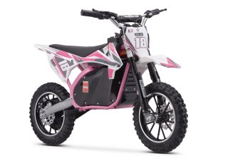
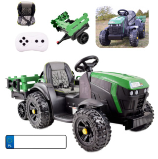
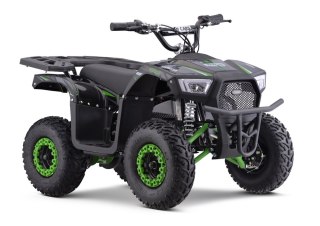
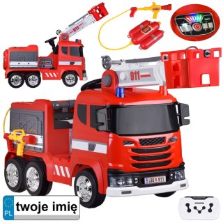
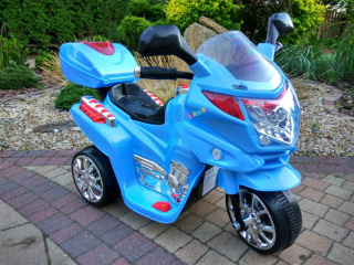
Safety Information
For use under direct adult supervision, Need to use protective measures. Do not use in traffic, Not suitable for children under the specified age. For use under adult supervision, This toy does not offer protection, Includes a toy. Adult supervision recommended
It has the CE mark confirming compliance with the requirements of the European Union directive for this type of device.
CE Declaration of Conformity | Complies with EN-71 - Safety of toys
For children over 3 years of age
It has the CE mark confirming compliance with the requirements of the European Union directive - Compliant with the EN-71 standard - Safety of toys